
24 Aug Improving McClelland Trail in Sugar House
Please provide comments in the form below.
By Colin Quinn-Hurst
SLC Transportation
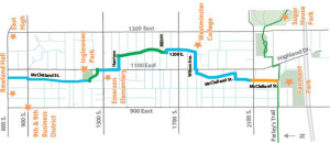 As anticipated in the Sugar House Circulation Plan, adopted by City Council in 2013, McClelland Street is rapidly becoming a gateway between the Sugar House Business District, the S-Line Streetcar, and Parley’s Trail. In addition, the planned McClelland Trail uses McClelland Street as a link between the section of the trail north of 2100 South and the section south of Sugarmont through Fairmont Park. With the projected increased in residential and commercial uses along McClelland in the near future, street improvements are needed to accommodate new residents, visitors to new businesses, and the new streetcar and trail users.
The Sugar House Circulation Plan originally recommended a widened sidewalk, a two-way bike path on the east side of roadway, creating a physical buffer separating trail users from vehicular traffic, and maintaining parking in one direction.
Using these recommendations as guidance, Salt Lake City is exploring a range of options for improving the street environment on McClelland Street. At this time, the City has developed three different possible layouts for that stretch of McClelland, and is compiling a report on the likely impacts and trade-offs for each different layout, including cost, parking impact, traffic impact, green space additions, street furniture improvements, timing of installation, and, above all, safety for all users of the street. Once all this information is compiled, all the options will be presented at community council meetings and on Open City Hall to get feedback and public direction on which option is preferred.
The three options in development are as follows:
1) Two-way vehicular traffic, parallel parking on the west side of the street, and a widened sidewalk and multi-use trail on the east side of the road;
2) One-way southbound vehicular traffic from 2100 South to Elm Street with angled parking on the west side of the street, two-way vehicular traffic from Elm Street to Sugarmont Drive, and a widened sidewalk and multi-use trail on the east side of the road, and
3) Two-way vehicular traffic, with intermixed pedestrian and bicycle traffic in a shared, plaza-type street in which all modes of travel share the street at slow speeds, with decorative pavers and landscaping creating improving the aesthetic feel of the street while slowing traffic to a safe speed. Images for each option are included below.
All options will include a “HAWK” pedestrian and bicycle crossing signal at 2100 South and McClelland Street, which will all pedestrians and bicyclists to stop traffic and safely cross.